Monday, June 25, 2007

Lucern and Klettersteig'n the Eggstock

Our trip this weekend started out with a nice little Saturday drive down to Lucern in Central Switzerland. We had made plans for Sunday which sounded at least a little bit physically taxing, so on Saturday we took it a little easier and constrained our "hiking" to Rick Steves' city walking tour. (Rick Steves, if you do not know, writes European guide books.) The most notable thing we saw was a cliff face, into which was carved a giant lion that could have swallowed me in a single gulp if he were not suffering from a spear wound, or, for that matter, made out of rock. I think that is a more interesting way of describing the size of the art than saying something like 30 feet by 20 feet.


The Swiss Army, not to be outdone by a rock carver from the eighteenth century, built a military fortress in the side of a mountain about 10 minutes from Lucern. Claiming student status, we walked around the decommissioned stronghold for two Swiss Franks a piece, exploring where and how they shot cannons out of the side of the mountain and learning a little Swiss history from a man who traveled through Sioux Falls forty years ago and still remembers it. And in 1958 they hid the artillery holes with a rock camouflage.

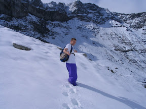
Sunday was the real adventure, though. Marianne, our gracious host, decided to kick her generosity level up another notch this weekend and take us rock climbing. Or more accurately, Klettersteig -ing. (As you can see, I haven't figured out the proper way to make German verbs out of German nouns.) We started out at 6am in the little blue car that we have recently become so familiar with and made our way down to the Glarnerland once again. One mountain-train, one Gondola, one chair lift, and a short hiking path later, we found ourselves at the face of a mountain. Strapping on some harnesses to keep our mother from worrying too much, we grabbed the wall and started climbing vertically. Actually, I probably should not rush through this—I'll give you a little more detail. In the mountain there are metal eye-rings every ten to twenty feet, and through these eye-rings is strung a long steel cable. Each harness has two carabiners a piece, so what you do when you Klettersteig is you attach both carabiners to the steel cable, then you climb a little bit. When you get to the next eye-ring, you detach one carabiner, reattach it on the other side of the eye-ring, and then detach the other carabiner and reattach that one on the other side of the eye-ring. This way, you are attached to the steel cable at all times, so if you fall, you are still more or less safe.


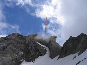
There were three different climbs, with the last one being pretty difficult (at least to me, who has never really done rock climbing before). The last one had some parts that were at least straight up, and it sure felt like it even had some parts where I was holding on leaning a little bit backwards, almost like I was climbing a bit of the underside of a cliff. It was really exciting, and being able to look down and see at least 100 feet straight down to the nearest piece of ground really pumped the adrenaline through my body. And then, of course, when we made it to the summit of the Eggstock, the view was splendid.


On the way down, Marianne explained little bits and pieces of all of the different types of flowers on the mountain face, including the Edelweisse which is a famous Swiss flower. We stopped at a restaurant and she ordered a drink called "Cold Chocolate." We thought we'd might as well try something new as well. When our drinks arrived, we found that unlike our exploration of Lucern, our new-found knowledge of the resilient Swiss military and our new ability to Klettersteig, not everything this weekend was a new adventure - cold chocolate turned out to be chocolate milk.

Sunday, June 17, 2007

Three Sisters

...We didn't know where we were going to stay the night. We planned to sleep in the car in some inconspicuous location and then hike in Liechtenstein on Sunday.

The only other time I've pulled over and slept in the car was near Great Sand Dunes National Monument in Colorado. We needed to get a camping pass for the weekend, but we arrived too late and the booth closed. We left and stopped on the shoulder of the road leading to the monument. There were no houses in sight and it appeared that the only destination of the road was the monument. It was a desolate location - definitely inconspicuous. Liechtenstein, on the other hand, is only 160 square kilometers (61.8 square miles), so I was more nervous about finding a desolate location.

But before we found our “hotel” we needed to find the trail head. This weekend our plan had been revised because it snowed at our first choice. Therefore, we did not have a good map of the region and only had an idea where the trailhead might be. We maneuvered the hairpins on the road from Vaduz to Triesenberg; then continued up the hill. At the end of the road was a parking lot. We had found our trailhead without much work.

By now it was almost dusk and there were three other cars in the parking lot. Ten minutes later one left. Now there remained a car with German plates and another whose driver and passenger were cozily checking out the lights of the city. We decided that the occupants of the German car were on an overnight hiking trip. It dawned on us that no one would care if we parked here over night like our new German friends. After the love birds left, we went to sleep in the back of our car. It was a relatively short night as the back was not that comfortable. We awoke to find a third car in the parking lot, but we were right that no one cared we were there.

We started our hike to the Three Sisters (Drei Schwestern). The first part of the trail seemed to be through an avalanche zone. There were washed out regions of the hill everywhere and cables were attached to the side of the mountain on the narrow trail. But contrary to yesterday, we could see everywhere, including the Säntis. It was incredible.

After about an hour we came through a pass and onto the ridge overlooking a lush green valley. Again, incredible. Not long after that Bryan decided that the previous day wore him out. He had been dragging a little from the start and said he wouldn't have any fun continuing. He decided to turn back, despite some mild resistance from me – I knew it wouldn't be as fun without him, but I didn't want to make him miserable either. He told me to keep going. He knew I wanted to get to the Three Sisters and into Austria.

He turned back, I kept going. I soon reached a peak, but it was only 30 minutes after a sign that said “Drei Schwestern 1 Std,” which means “Three Sisters 1 hour.” Usually we hike a bit ahead of the pace of those signs, but I was very surprised I would be there in half the time after being a bit worn out from the previous day. I saw some other peaks a head and the one I just submitted was not one of three anythings. I pressed on.

I got to Garsellikopf. This, I later found, was on the border of Liechtenstein and Austria. The marker at the top said 2105 meters and had an arrow with “Drei Schwestern” on it. I had not yet reached the goal. I went down from Garsellikopf and continued along the ridge. This ridge composes a natural border between the two countries. The views on both sides of the ridge were awesome. It is really hard to come up with good adjectives for the beauty of what we take in. Hopefully, my pictures help, but they hardly do it justice.

Not long after Garsellikopf I found a sign that said ½ hour more to my goal. At this point I was a little upset with the sign makers because there was no way I could have made it from the first sign to this one in ½ hour, even if I was not tired. After a short break for mumbling, I took a slightly longer one for kissing the new toe injury I received from kicking the sign post; then I continued. Eventually I made it to the first of the Drei Schwestern. I took the following picture sitting with my legs around the marker (it was steep at the top and I was tired). The two crosses on the peaks are the other Sisters. To the left in the foreground is Liechtenstein. To the right is Austria. Farther ahead to the left is Switzerland. And on the other side of the giant lake in the distance is Germany.

On the way down, I made good time. I, in fact, dominated the sign post makers, reaching the bottom in two hours (compared to their expected three, but that's how long they said it would take to summit as well). After those hikes, Bryan and I were exhausted.

As usual, please enjoy perusing the pictures; take a look at our destination map. We'd love to read any comments.

Säntis

This weekend's story once again begins with the overwhelming generosity of our hostel hostess, Marianne. She was not going to be using her car this weekend, so she practically forced us to use it. So, we loaded up the blue Subaru wagon, and set forth with road map in hand.

Despite a noticeable lack of knowledge of laws like the unposted freeway speed-limit and proper round-about etiquette, we arrived safely and without major incident at a little town called Wasserauen, from where we took a chair lift to the beginning of our hike. The weather was pleasant, although a little foggy, our bags were light because we could leave most of our things in the car, and our destination, Säntis, was calling.

Once again, I'll skip over most of the four-hour hike because the pictures give a better description than I can, so we'll pick up the story three and a half hours in. We knew we were getting close to our destination, but because of the fog we really had no idea how close. All we could see was a big snow field in front of us so, learning from past experiences, we switched from our light-footed running shoes to our heavy-duty hiking boots and started the climb. As we ascended with hardly an idea where we were going, the weather gradually became colder, dropping to a frigid 3.5 degrees Celsius (or roughly 40 degrees Fahrenheit). Finally, we came to a 'T' in the hiking path and, not having any signs to guide us, we had to make a decision: climb the peak to the left or climb the peak to the right. We climbed the left peak, which turned out to be the correct peak, and entered the tourist trap known as Säntis.

Our hike to Säntis took us four hours. Most people's lift rides to Säntis took them four minutes. So, we did not have a real solid mountain-top experience this time (unless your idea of a mountain-top experience involves eating nuts—a popular hiking staple in the Burgers' hiking supplies—in a warm restaurant above a souvenir shop) but the fact that we conquered the mountain was good enough for me.

Sleet began to fall as we left. Then, the fog lifted, and we saw a huge weather tower on the top of Säntis, one so big that it not only would have make the choice glaringly obvious which of the two peaks to climb, but would have shown us exactly where we were going through the snow fields. In fact, three hours later when we reached our starting point again, we could still plainly see the tower in the distance.


Having finished our Saturday adventure, we crawled back into the car, found a nice little place to eat pizza, and then went off in search of a good place to sleep for the night...

Happy Father's Day

Happy Father's Day, Dad!

You've done tons for us and the four of us are very thankful.

I was thinking this weekend about the when I was about 12. The three of us would complain how we had never flow in an airplane. We had to drive all the way to California (and on the way saw the Grand Canyon and other things) to visit the family and Disneyland. What'd you do? You organized a plane ride for us. I just remember wearing the head set and seeing Grandpa and Grandma's farm. Exhibit #81921 on why you're a great dad.

Thanks! Travis, Rachael, Stephen and Bryan.

Sunday, June 10, 2007

Lake Geneva, Avanches and Bern

This weekend we decided we’d let the snow melt a little more in the mountains and take a break from hiking – but not a break from recreation.

Bryan wanted to go for a bike ride. We read that if we had a security deposit and a passport, we could get free bikes for the day in Lausanne. Well, we could manage both of those – there, we had our regional destination. I also saw some great pictures of a chateau on the lake – there, we had our specific goal. When we inquired about some hostels in the Lake Geneva area, we were surprised to find there was no room in the inns (hostels, at least). But we were stubbornly intent on going out West. Plan B was to go to Lausanne early on Saturday, go for our little bike tour, and return part of the way Saturday night. Finally, we found a hostel in Avenches, but we had to be there by 10pm.

Because of our arrival deadline, we woke up before the early-morning Swiss sun could rise and we set off for Lausanne. We arrived and after a little difficulty, found the bike “rental” location. My heart sunk a little bit when I found out the bikes were cruiser touring bikes, not road bikes or mountain bikes. Later we found that the touring bikes made our necks hurt since everyone passed us so quickly on their road or mountain bikes.


Not long before we got our bikes we found out that the Chateau de Chillion was about 30 km (18 miles) from Lausanne – not the 15-20 km we were thinking. But since we arrived early, and despite our bikes, we thought we could go round-trip and still make the last train that would get us to Avenches. The ride was beautiful. We took a road with a steep hill on the left and the shoreline on the right. The steep hills were covered with grape vines from a number of vineyards. Stunning.


We arrived at the Chateau and took a tour. Then chateau was made famous by a Lord Byron poem set there about how Bonivard was chained to a column in the prison for five years. It was similar to other castles I’ve seen, but it was still interesting.

By the time we returned to Lausanne we were tired – at least I was – Bryan seemed a bit fresher. I was wondering if I hit my 36-mile-wall and Bryan’s was coming at 38 miles or something. I got off my bike and tried to spin the tires to see how they’d work – I thought maybe the brakes were rubbing or something. When I lifted each wheel off the ground and spun it, I could barely get them to spin two rotations with a little push. Bryan’s was working better. At that point, I was very glad I hadn’t tried that before. I’m not sure I would have been willing to ride so far with a bike about as efficient as my old Huffy. We found that we stopped just a little way from the Olympic Museum. We viewed some art in the courtyard of the Olympic Museum and saw the Olympic flame. We then returned the bikes and made it Avenges in time for the 10pm check-in.

Aventicum was once the capital of the Roman province of Helvitica. What was left for us to see in Avenches was a Coliseum-style amphitheater (except without the outer wall) and a few Roman ruins. Early Sunday morning we walked in the footsteps of past Centurions and visited the remains of a theater and a column from an ancient temple. We then both enjoyed our short time in the Roman museum and continued on to Bern.

Bern was crazy when we arrived. There was the Schweizer Fraulaufen, which is an event where every Swiss woman who ever lived ran some course. Coincidentally, every kid was spinning a ratchety, annoying noise-makers provided by Coop. (Bryan and I have since organized a boycott.) We tried our best to avoid the race course and continued through the Swiss capital. The highlights of Bern were the eleven old fountains, the flag-lined streets (I love flags), the clock tower and the bear pits (even though in the five minutes we spent there we took disproportionaly more pictures than in the rest of the city).


As usual, the highlight of the blog is probably the pictures – there are two albums this week, one for the Geneva countryside and one of Avenches (not many) and Bern. We hope you’re enjoying the backseat trip so far – no we’re not there yet. Please let us know if it’s too hot back there, you think we’re taking the corners too fast or you want to listen to a different radio station.

Monday, June 4, 2007

More Hiking Adventures


The plan for this weekend was more hiking.

Marianne (the lady that runs the hostel) and Daniel offered their home in Glarus as our home base for this weekend, so we rode down with them on Friday night, chilled out for a while and slept. In the morning, we were treated to a fantastic breakfast and a pretty solid lunch before heading out for our Saturday afternoon hike. Our weekend plan included a pretty difficult pass on Sunday so we were planning on taking it easy on Saturday.

We jumped on a lift in the early afternoon which took us from the slightly foggy city of Enninda halfway up a very foggy mountain. There was a point on the lift where I could probably only see five feet away from myself. But where the lift stopped it was a little more clear, and we started hiking.

Our hosts told us we should have hiking boots and lent us some of theirs, and we started out in those. After about fifteen minutes of climbing, Travis and I both decided that the boots were ridiculous and we were better off in our running shoes. And as we climbed more, it became very evident why our hosts urged us to wear them: despite the fact that they feel like somebody tied a ball and chain to our feet, the boots kept our feet very, very dry. Without them our feet were soaked within minutes. We climbed a ways more before deciding we had gone far enough, seen enough and wanted to conserve our energy for the next day, so we hiked back down.

That night, we played a sweet game of Cuboro.

Sunday morning started early. We rose before sunrise, ate some breakfast and headed toward the train station, which took us to a bus station, which took us to a road, which took us to a chair lift. Or a Sielbahn if you understand German. I don't. We learned our lesson the day before, so we put on the dry ball-and-chain hiking boots that we borrowed from our hosts and started trudging.


Our trail started up a big mountain covered in white. But not snow—sheep. There was even a shepherd in the field. Many of the sheep were standing on our path, so Travis had to shoo them away before we climbed up the mountain. As we continued to ascend, crossing several roaring rivers on the way, the views just continued to get better. And, as we continued to ascend, the path went from dry to muddy, to a little bit snowy, to really snowy. And then, the path stopped. Well, at least the tracks of other hikers from earlier this year. We could not see the path anymore, because all we could see is snow. We decided, however that we wouldn't let the snow stop us, so we searched around for the trail markers on the rocks and started blazing our own trail through the snow. First, the snow was up to our ankles. A few hundred feet more, up to our boots. Up to our knees. Finally, up to our hips. We were so close to the pass, but we decided it was just too dangereous, since the original trail blazers probably had ropes and not school backpacks; or else went in August. So in the end we decided that we would let the snow stop us.


We came back down to the chairlift, and my feet were screaming "Get me out of these boots!" and if you know me, I don't often argue with my feet when they are screaming, so I obliged. We sat at the chair lift for a while, occassionally using what was probably the second phone Alexander Graham Bell made, spinning a dial to make it ring, calling the bottom hoping somebody would answer to bring us down. But nobody did, so we decided to take the hour-long trail toward the bottom. There was no way our feet were going back in those hiking boots, though, so we laced up our running shoes and started hiking. Our feet were so happy to be in running shoes again, they practically floated down the hill until we started jogging down the path, jumping from rock to rock, taking rivers in a single bound and balancing on tree trunks until we reached the bottom. Then, another bus, a few more trains, a stop in Zurich for some kababs (!!!), and we were back home at the Hostel.

See all photographs