Sunday, August 19, 2007

The "family"

Here is a picture of me with our "host family" -- well, at least the family at the place where we stayed. Marianne, Jolanda and Sebastian. Bryan had already left so he didn't make the picture.


Tuesday, August 14, 2007

Canton Flags

During our stay in Switzerland, we visited 21 of the 26 cantons. Interestingly, each of the five we did not visit borders France.

The flags are all square, just like the Swiss flag should be. They are shown in the order visited (in columns), I think.


The ones we visited (21 cantons, #2-22):
1. Switzerland
2. Zurich
3. Aargau
4. Solothurn
5. Bern

6. St. Gallen
7. Glarus
8. Fribourg
9. Vaud
10. Appenzell Ausserrhoden

11. Appenzell Innerrhoden
12. Thurgau
13. Lucern
14. Nidwalden
15. Uri

16. Schwyz
17. Zug
18. Ticino
19. Graubunden
20. Valais

21. Obwalden
22. Schaffhausen

The ones we did not visit (5 cantons, #23-27):
23. Geneva
24. Neuchatel
25. Jura
26. Basel-Stadt
27. Basel-Landschaft

If you got this far, you may be a nerd like me (Darin!). I think there are some very good flags. My favorite changes from day to day, but more days that not, the Bern flag is number one. As I told Bryan, some days it even surpasses the Swiss flag, but the Swiss flag is consistently my favorite.

But there are also some terrible ones. My least favorite is Ticino. Today Neuchatel is rubbing me wrong as well. I don't want to list all the others I don't really like because I'd love to read some other opinions. Follow this link for a better look, and a map, if you like.

Monday, August 13, 2007

Vrenelisgärtli

The Last Trip. This was a bookend trip.

I made arrangements to meet Marianne, my host-mom of sorts, and her husband Daniel in Schwanden on Saturday afternoon because they’d been hiking the previous week. I took the train there via the Zürich HB, where there was some crazy festival with people wearing crazy costumes (or not wearing much of a crazy costume, if you know what I mean). We met as planned and drove to the trailhead. They loaded me up with a bunch of gear that I would need and we set off about 6pm.

We hiked for about two hours and reached a saddle maybe 800 meters above our start. Usually this summer, I was the map holder and guide. This time, for most of the way, I had only a basic idea of where we were and where we were going. For this reason, I don’t really know how far we went. But once we got there, we spent the night at the Guppenalp. This was a summer farm house for the Senn. The Senn are more prestigious than farmers (that’s what I was told Grandpa, I didn’t say it!) because they are the ones responsible for the cows. This is a big job because they have to move the cows up the mountains in the summer; they do this because the valleys don’t have enough grass for the whole year. There are three grass “tiers” and this hut was on the third tier. Huts like this are called “alps” – so we stayed at an alp in the Alps. Here is a picture of the alp and the myth, the legend, the wonderful Marianne.


From the alp there was a beautiful view of the sunset. I’m afraid that this may have been the worst weekend for the pictures though. Later that night I woke up and walked outside to the outhouse. On my way back inside I was a bit cold but I had to stop in my tracks. The sky was crystal clear. My stuttering fingers cannot begin to describe how the stars overwhelmed me. The sky was blanketed with every star that was ever created. It was marvelous. This was just one time of many this summer that I have been blown away by the Creator.

The next morning we awoke before the sun. At breakfast I was served a saucer of fresh milk – like a cat – and enjoyed it. We set off at 5:45 because we had a big day ahead of us. On the way up we did a lot of “scrambling” which is somewhere in between hiking and rock climbing. There were a few difficult, steep spots where I was a little nervous.


Near the peak we got to a small snowfield. I put on the cramp-ons (spikes for my boots – yes I wore boots this weekend) and the harness. I was instructed how to use the ice axe. Then we uneventfully hiked up a snow trail. A bit closer to the summit we tied the rope between us and did something that more closely resembled climbing than scrambling.

Finally (maybe 10am) we reached the Vrenelisgärtli. The summit was 2900 meters, about 2200 above where we had started the afternoon before and 1400 or so above where we started that morning. The beauty of this peak is that we could see it for much of the summer. It is visible from our room on a clear day and it was visible on a number of our other hikes. We had lunch at the top and Marianne supplied me with some Pistachio nuts and yet another Schoci Stanli. Unfortunately, there were many clouds at the summit, but much of the day was clear, so I cannot complain.

Almost immediately after starting our descent down towards the glacier, I promptly slipped and cut my hand. Ugh. I never did feel comfortable in the rigid boots and had a hard time feeling the ground. But I was being a bit careless too. It was just a wide scratch but it bled for a while.

Not far from the top we reached the Glärnisch Glacier. We walked about 30 feet apart with the rope tight, in case one of us would fall into a crevice. I saw one or two crevices but this was thankfully an uneventful stroll through the snow field. After we walked about a mile we reached the end of the glacier. We sat down to remove the cramp-ons and heard the whirring of a helicopter. Dani got out his binoculars and we watched as a rescue crew was unloaded. Later we found out that a man, hiking alone, had fallen 30-40 meters. He was airlifted out to safety.


A little farther down the trail we arrived at the Glärnischhütte. In my mind I had been thinking of this moment for a few hours. This was my intermediate goal. I knew once I got to the hut, my feet would sing for joy because it was time to take off my boa constrictor boots and put on Icarus’ shoes. We took a much-needed extended break at the hut, because we had only taken a few short ones up to that point. Then we hiked down the valley.

I won’t describe the rest of the trip to the Klöntalersee because you’ve heard it before. What I mean to say is that we wrote about it on our first weekend hike. This weekend was a bookend trip because the first hike Bryan and I did was to go up this valley to the Glärnisch hut and then to the glacier. This time, thanks to my guides Daniel and Marianne, we reached the hut from the other side, after summiting the highest peak in the Glarnerland. I also had the opportunity to use the cramp-ons, ice axe, and rope for the first time. It was a fun trip.

As I sit overlooking Winterthur on this cool, peaceful evening, I realize that there will be a lot to miss about this place. But I am also looking forward to going home as well. I hope to do a little more summarizing yet this week, but we’ll see how that goes.

Tuesday, August 7, 2007

Reflection

Today is already Tuesday, which means we are at least two days late posting our weekly weekend blog. The reason behind this is simply that we chose not to create an adventure this weekend, so there is nothing epic to write about. However, it would be a travesty to deprive our loyal readers of a passage to read, so I want to write something. And, since my remaining time in Switzerland is now being counted in hours rather than days, weeks, or months, I thought this would be a good opportunity to jot down some of my reflections on this summer.


Now that I sit down to write my reflections though, I seem to be at a loss. We travelled quite a bit, hiked on a fair share of mountains, and saw a fair share of nature. I lived with my brother for the first time in probably eight years, I worked full time from my apartment, and I read more than a handful of books. I did some common things and I had some new experiences. But still, I can not say that I feel any different or that there are any huge life lessons that I will take away from this place. Or maybe I should say, there are no huge life lessons that I can take away from this place right now. What I discovered after my trip to the Netherlands is that, after living there for a couple months, I simply became accustomed to most things, and it was not until I was home again that the things I learned an experienced began to manifest themselves in various ways. I hope things will be similar this time around.

I do know this, though. Living in a different country, experiencing different cultures and attitudes, seeing new sights, and all of the other wonderful things about travelling are great and I am truly thankful for the chance I had to live in Switzerland this summer. At the same time, coming home after a long trip is also an awesome experience. Even though my time in Switzerland has been awesome and I will miss this place dearly, I am still overjoyed to be counting my remaining time in hours rather than days, weeks, or months. I hope to see you really soon!

Nüenchamm

Travis thought we should write at least a little something about our August 1 (Swiss National Day) trip last Wednesday.

All along we've been saying, "The pictures say it better than we can describe it," so this time I'm going to subscibe to that, which means this post basically serves as a link to the pictures.

Sunday, July 29, 2007

Blüemlisalp

This week we made a return to Berner Oberland. We drove to Kandersteg and began from there. The first hour of our trek we passed about thirty members of Troop 101, as we called them. This was a disjointed group of kids, maybe 14 years old or so, evidently on a camping/hiking excursion. About an hour into our trek we reached the Oeschinensee. There was a restaurant/hotel there and this was, thankfully, also the final destination for the Troop. We continued along the path to get away from the crowd of kids, many of whom already had reached the lake. We walked on the north side of the lake from west to east and took in the magnificent view. The lake was fed by numerous waterfalls and had a stunning shear cliff making up its east bank.


After we climbed out of the valley we found that we were in another, but we could no longer see the lake. Here we could more clearly see one of the sources of the lake: the Blüemlisalp Glacier. The glacier had some loud waterfalls coming from its melting edges. A few spots were a wonderful blue color, but most was a dirty color because it is the middle of summer.


After a few more hours we reached the pass. We climbed a little farther and stopped to rest at the Blüemlisalphütte. Fortunately, we filled up our water at that restaurant because there was no potable water here (then we questioned the potabitality of the water at the restaurant too). We felt a little out of place at the hut. Let me explain. First, the high temperature for Kandersteg was supposed to be 23° C. The temperature drops about 1 degree per 100 meters of elevation change. The hut was 1600 meters above Kandersteg, making it about 7° C (~45° F) max. We (well, thanks to our fearless leader, me) foolishly did not bring any long sleeves or jackets and our hands were a little numb when we reached our goal. Everyone at the hut was wearing their waterproof, windproof hiking gear. We had hiked in cotton t-shirts and shorts. Second, we have noticed that if you hike, you have to wear 3 pound hiking boots, otherwise you can't walk over rocks. Bryan and I both feel much more comfortable and stable in our running shoes. But we did see a pair of tennis shoes on the rack where we got our indoor, hut footwear! They must have been packed along by one of those staying at the hut for the evening. We got a bowl of hot soup and a chocolate bar and warmed up slightly before our descent back to Kandersteg.

About 15 or 20 minutes from the hut, we were already down far enough to be warm again. To that point we had passed a number of other descenders. It was probably because they were bogged down in their hiking boots. (In fact, on the whole day, other than our rest breaks, only at the end when we were marveling at some cool tree carvings did we get passed by someone.)

This hike this week was a particularly big one. If you are familiar with the metric system you may have caught I mentioned the magnitude of our ascent: 1600 meters (if not the number didn't mean anything to you). Actually, it was 1660 meters. For those of you who aren't familiar, 1600 meters is 1 mile. If you're from South Dakota or Wisconsin on the Great Plains, every square foot of the plains is exactly 1100 feet. Well, Sioux Falls is about 1400 feet and Madison 900 feet. Denver, the Mile High City, is 5280 feet. The elevation change of our hike was more than the difference between the plains and the base of the Rockies. Because of this, I was a little surprised by the people that we saw in the hut, those who looked down at us foolish kids for wearing tennis shoes and t-shirts. There were a few people of retirement age. A number of others were, well, maybe I should just say that there weren't too many people in their 20s as I would have expected after such a climb. I guess that means we're not so special.


Today we have been paying the price for the hike because we have been hobbling around. But the trip was worth it because we feel a little sense of accomplishment after such a big hike. A better reason that it was worth it was because the lake and glacier were brilliant. Again, it's so hard to describe and it's even better than the pictures can show.

Wednesday, July 25, 2007

Rheinfall

Bonus midweek blog!


A few times this summer Marianne has suggested we go to see the Rheinfall and I heard Mariana say that it was worth seeing. Finally, we decided that it was a good evening to go. Marianne and family went to Italy for a few weeks and left us the car again. We tried to find anyone else who wanted to ride along on the half hour drive to Neuhausen am Rheinfall, but nobody at our place wanted to go.

I had heard claims that the Rheinfall is the biggest waterfall in Europe. When I first heard that statement I wondered what it meant exactly. Tallest waterfall? Nah, Schmadrachfalle (from our last trip) was definitely taller. Most water? Widest? I'm not exactly sure, but I bet it means it is the waterfall with the most volume of water.


The waterfall, or series of falls, occurs at a bend of the Rhein River. The Rhein begins in Switzerland and makes up part of the border between Switzerland and Leichtenstein, Austria and Germany. Later the Rhein makes up about half of the border between Germany and France. Finally it flows through the Netherlands and into the North Sea. In the Netherlands it splits and one part becomes the IJssel [sic], which separates Zwolle and Hattem. These seemingly insignificant towns are where Bryan used to live and went to school, respectively, during his semester in the NED. But enough geography that few beside me really care about.

Back to the falls. I was not expecting them to be quite as big and I was quite impressed. After a little bit of research, we found that they are approximately half as tall with 10% of the volume as Niagara Falls. But I've never seen that and Bryan and I agreed that these were easily the biggest we've ever seen. To add to the experience, the evening was very calm and the peaceful warm weather contrasted nicely with the roaring falls. There was a time where we stared into the falls, mesmerized as if they were a fire.

There isn't really much to write about our quick trip to the falls. Sometimes I think maybe we should just post a link to the pictures instead of writing, because really, they tell the whole story.

Monday, July 23, 2007

this weekend's non-adventure

are you ready for this
we wrote you a rhyme
we’ll make this quick
it won’t take much time

we thought we should ‘splain
why we have nary a pic
why we didn’t go adventuring
or follow guidebook Rick

the forecast called
for clouds and some rain
so here in our room
we thought we should remain

the dark angry clouds
began their Saturday pour
the hall window was open
you shoulda seen the wet floor

someone forgot it
he wasn’t using his head
but he paid the price
with some saturated bread

we stayed in our room
and were quite content
watching the clouds
as projectiles were sent

thunder shook the house
and bright lightning flashed
by then our hopes for a hike
had long since been dashed

we might have been fine
on Sunday afternoon
but after the rain
we felt it was too soon

one weekend at home
is considered a rest
but if there are no more
that would be best

t&b

Sunday, July 15, 2007

Schmadribachfall

"That's a nice picture." Yep, that's what I just heard while Travis was uploading the pictures today. And once again, this week the story is in the pictures. Go ahead, go and look at them right now if you'd like, I won't be offended. The blog will still be here when you return.


We went hiking again this weekend. This time, we went to central Switzerland to a place a little south of Interlaken, which we wrote about last week. Travis' boss Robert was taking his three-year-old son to Interlaken and so we hitched a ride with him, and Rick Steves (the author of our Switzerland guide book) tipped us off about a hike from a little non-touristy town named Gimmewald. We had to take a lift up to Gimmewald, and it did seem like a fairly down to earth little village; at least all of the houses were made of unpainted wood.


The first stretch of our hike was difficult. We walked up what seemed to be a 45 degree incline for about an hour, and to make matters worse there was very little of a view to make us feel better about our sweat-drenched shirts and complaining lungs. But after that first hour, we realized it was worth it. Well, more accurately, after we passed the bulls that were guarding the path, standing right on our path looking straight at us, and demanding that we answer them these questions three (I got one wrong and Travis rescued me from the Gorge of Eternal Peril, but that's a different story for a different time), we were allowed to pass and we realized it was worth it. And here's why: we reached a high point called Tanzebödeli where we could see out over the fertile valley with its quaint mountain villages and across the valley to three looming white-peaked mountans and two lively water falls, and it was breathtaking. Well, it would have been if the difficult climb hadn't already taken my breath.


Our trip down the other side of the mountain was much easier and we had a good view of Schmadribachfall nearly the entire way down. That's the big waterfall in the pictures. And that was our first trip to the Berner Oberland. We fully plan on going again soon, and you can be sure that when we do, we'll take even more pictures.

Sunday, July 8, 2007

Fast-Forward Sightseeing

What a tour book writer could see in a week, Travis and I did in one whirl-wind tour of a day. In other words, if a normal trip through Switzerland is a movie played at normal speed; Travis' and my Saturday was the same movie in fast forward. Basically what I'm getting at is that we mananged to visit three of Switzerland's top attractions in one day: Zermatt, Interlaken, and Zurich.


Tracking the Zermatt weather for the past week, we were convinced that the weather would be pristene on our trip to see the famous Matterhorn. We had heard, and Travis had experienced, that often the weather around the Matterhorn is foggy and hazy and there is not really a good view of the mountain; however, while we sat and stared at the mountain, there was not even one cloud in the bright blue sky. I think the pictures are the best way for you to vicariously experience the mountain jutting straight up. After spending about two hours in Zermatt, we jumped on the train and headed back down the mountain toward a town called Interlaken.


Interlaken means "between lakes," so we made a point to see one. But Interlaken is also a very touristy area, so we made a point to browse a few souveneir shops on the way. After walking on the main shopping street for a kilometer or two, we veered off the main road and found the Aare River which connects the Thunersee and Brienzersee (the two lakes) and followed it to Brienzersee. We soaked in the scenery—the huge blue lake with a bunch of mountains in the background framed by the big blue sky—from a small dock. Actually, just go and look at the pictures for this one, too.


Zurich, although it was not on the original itinerary, has a great place to buy Doner Kabobs in the train station, so, since we were hungry and since Zurich is almost always on our way back to Winterthur, we decided to grab some of the seasoned lamb. Upon arriving in Zurich, Travis remembered someone telling us earlier that week that it was Zuri-fest, a huge festival. Since it was only 8:00pm, we decided to see what all of the hubbub was about. A few other people also decided to see what it was about, and pretty soon we were in the middle of a huge crowd and could barely move. There was some music, but none that really appealed to either one of us—it was much more fun just to dodge in and out of diverse mob of people present as quickly as possible than to listen to the techno that was blaring on the side streets or the German music on the main stage.

Eventually, we navigated the singing and dancing crowds back to the train station. But the day ended as the rest had gone, in fast forward. We made use of our people-dodging, through-crowd-weaving practice by sprinting through half of Switzerland's busiest train station to catch our Inter-City back to home-sweet-home Winterthur. On the train back we refelected on our wild day—we awoke before dawn, spent a total of 11 hours on trains (luckily we purchased day cards and got more than our money's worth out of them) and saw several of the major Switzerland tourist attractions. The sights made all the travel well worth it, and frankly, we wouldn't have it any other way.

Sunday, July 1, 2007

Ticino

As more entries are crossed off our "Places to Visit" list, the remaining locations are becoming farther away. We looked at the weather and the Ticino region promised to be the driest of those remaining. After we decided where to go, we told Marianne and asked for input. And, in what is becoming a pattern, she gave us advice and offered us her car.

On Friday I got off work a little after noon and we drove through the 17 km (10ish mile) Gotthard tunnel to the canton of Ticino in the Italian region of Switzerland. We arrived in Lugano and walked around a little bit. Lugano was beautiful – it's a city right on a lake with hills rising right out of the water. But it is not the most exciting town and we had reserved rooms elsewhere and left after only a few hours.


We then navigated a narrow, curvy road up to Miglieglia. The straight portions were about 10 car lengths long and I was a little nervous. When rounding one left-hand curve heading up hill, I was minding my business, driving on my own side of the road, safely, and I met a Jeep that came whipping around the curve well over the line. He promptly made his tires squeal but didn't appear to want to return fully to his lane; still, everything turned out OK.

After arriving in the town of Miglieglia, we immediately saw the lift that we planned to ride up to Monte Lema where we would stay in a hotel with the same name as the mountain. We parked the car and found that the lift closed at 5:30 for the evening. It was 7:30. We were late. We were a little disappointed, but fortunately we have been practicing our hiking and we unexpectedly hiked up about 2000 feet to our hotel. As we reached the top, we saw the high Alps rise like the sun above the ridge. Wow. We were shown our "dormatory" style room and found that we had the 10 beds to ourselves. We then took a brief walk into Italy and went to bed early.

On Saturday morning we trekked up and down along the top of the ridge to Monte Tamaro. In the morning it was clear to the west and we could see to the snow-covered high Alps in central Switzerland. In the east it was a little hazier, but we were still impressed with the hilly Ticino.


About half way to Monte Tamaro we saw our first hikers. As we approached we saw more and more because there was a lift much closer to Monte Tamaro than the one we wanted to take. By the time we summitted, there were many others. Am I selfish if I walk about 6 miles, see about 8 people all morning, then have to share the peak with 15 others? Nonetheless, the view was awesome. At 1962 m, we towered above Locarno and Lake Maggiore (193 m). We hiked back to Monte Lema, making it a game to catch everyone in front of us. We caught everyone we saw, except for two groups of two, one of whom we would have passed if they didn't take the other trail three minutes from Monte Lema. That's right, I'm still bitter.


This time, we caught the lift down. Back in the car, on the road to the freeway, I was beginning to miss the road we took up to Miglieglia. Now the road was about a lane-and-a-half wide and it was even curvier! – in one section there were about 8 hairpins in a row. Fortunately, the other drivers were more well-behaved than on the way up; still I was terrified. The only incident we had was when I faced off with a bus like two rams fighting for a ewe. I changed my mind and decided that the ewe wasn't even that attractive. I pulled into a driveway so the bus could take his conquest on the one-lane section of road and saved my horns for one with shinier wool and smoother hooves.

Ticino was much different than the higher mountians we've climbed already, but we still enjoyed the different scenery. Possibly, more importantly, the new marker adds breadth to our map. The weekend seemed a little less eventful than the previous ones, maybe because as I look back, this is the first weekend in June we haven't been gone on both Saturday and Sunday. It is good to take a little break today.

"What remains on that list of yours?" you ask. SPOILER ALERT. Among our plans is to meander near the Matterhorn and take a jaunt or two in the Jungfrau region. Stay tuned...

Monday, June 25, 2007

Lucern and Klettersteig'n the Eggstock

Our trip this weekend started out with a nice little Saturday drive down to Lucern in Central Switzerland. We had made plans for Sunday which sounded at least a little bit physically taxing, so on Saturday we took it a little easier and constrained our "hiking" to Rick Steves' city walking tour. (Rick Steves, if you do not know, writes European guide books.) The most notable thing we saw was a cliff face, into which was carved a giant lion that could have swallowed me in a single gulp if he were not suffering from a spear wound, or, for that matter, made out of rock. I think that is a more interesting way of describing the size of the art than saying something like 30 feet by 20 feet.


The Swiss Army, not to be outdone by a rock carver from the eighteenth century, built a military fortress in the side of a mountain about 10 minutes from Lucern. Claiming student status, we walked around the decommissioned stronghold for two Swiss Franks a piece, exploring where and how they shot cannons out of the side of the mountain and learning a little Swiss history from a man who traveled through Sioux Falls forty years ago and still remembers it. And in 1958 they hid the artillery holes with a rock camouflage.

Sunday was the real adventure, though. Marianne, our gracious host, decided to kick her generosity level up another notch this weekend and take us rock climbing. Or more accurately, Klettersteig -ing. (As you can see, I haven't figured out the proper way to make German verbs out of German nouns.) We started out at 6am in the little blue car that we have recently become so familiar with and made our way down to the Glarnerland once again. One mountain-train, one Gondola, one chair lift, and a short hiking path later, we found ourselves at the face of a mountain. Strapping on some harnesses to keep our mother from worrying too much, we grabbed the wall and started climbing vertically. Actually, I probably should not rush through this—I'll give you a little more detail. In the mountain there are metal eye-rings every ten to twenty feet, and through these eye-rings is strung a long steel cable. Each harness has two carabiners a piece, so what you do when you Klettersteig is you attach both carabiners to the steel cable, then you climb a little bit. When you get to the next eye-ring, you detach one carabiner, reattach it on the other side of the eye-ring, and then detach the other carabiner and reattach that one on the other side of the eye-ring. This way, you are attached to the steel cable at all times, so if you fall, you are still more or less safe.


There were three different climbs, with the last one being pretty difficult (at least to me, who has never really done rock climbing before). The last one had some parts that were at least straight up, and it sure felt like it even had some parts where I was holding on leaning a little bit backwards, almost like I was climbing a bit of the underside of a cliff. It was really exciting, and being able to look down and see at least 100 feet straight down to the nearest piece of ground really pumped the adrenaline through my body. And then, of course, when we made it to the summit of the Eggstock, the view was splendid.


On the way down, Marianne explained little bits and pieces of all of the different types of flowers on the mountain face, including the Edelweisse which is a famous Swiss flower. We stopped at a restaurant and she ordered a drink called "Cold Chocolate." We thought we'd might as well try something new as well. When our drinks arrived, we found that unlike our exploration of Lucern, our new-found knowledge of the resilient Swiss military and our new ability to Klettersteig, not everything this weekend was a new adventure - cold chocolate turned out to be chocolate milk.

Sunday, June 17, 2007

Three Sisters

...We didn't know where we were going to stay the night. We planned to sleep in the car in some inconspicuous location and then hike in Liechtenstein on Sunday.

The only other time I've pulled over and slept in the car was near Great Sand Dunes National Monument in Colorado. We needed to get a camping pass for the weekend, but we arrived too late and the booth closed. We left and stopped on the shoulder of the road leading to the monument. There were no houses in sight and it appeared that the only destination of the road was the monument. It was a desolate location - definitely inconspicuous. Liechtenstein, on the other hand, is only 160 square kilometers (61.8 square miles), so I was more nervous about finding a desolate location.

But before we found our “hotel” we needed to find the trail head. This weekend our plan had been revised because it snowed at our first choice. Therefore, we did not have a good map of the region and only had an idea where the trailhead might be. We maneuvered the hairpins on the road from Vaduz to Triesenberg; then continued up the hill. At the end of the road was a parking lot. We had found our trailhead without much work.

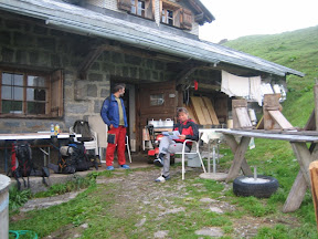
By now it was almost dusk and there were three other cars in the parking lot. Ten minutes later one left. Now there remained a car with German plates and another whose driver and passenger were cozily checking out the lights of the city. We decided that the occupants of the German car were on an overnight hiking trip. It dawned on us that no one would care if we parked here over night like our new German friends. After the love birds left, we went to sleep in the back of our car. It was a relatively short night as the back was not that comfortable. We awoke to find a third car in the parking lot, but we were right that no one cared we were there.

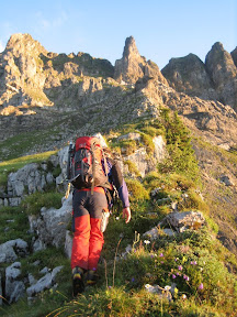
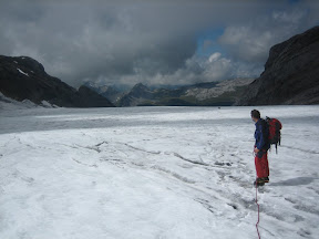
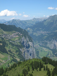
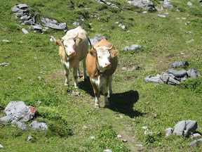
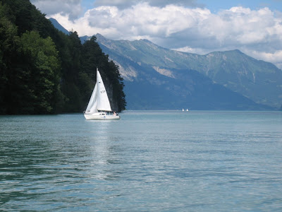
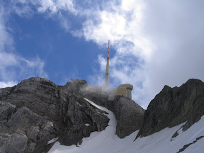
We started our hike to the Three Sisters (Drei Schwestern). The first part of the trail seemed to be through an avalanche zone. There were washed out regions of the hill everywhere and cables were attached to the side of the mountain on the narrow trail. But contrary to yesterday, we could see everywhere, including the Säntis. It was incredible.

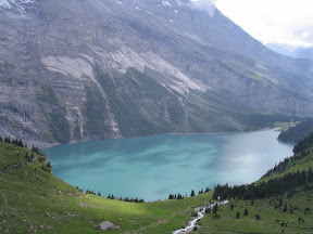
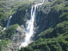
After about an hour we came through a pass and onto the ridge overlooking a lush green valley. Again, incredible. Not long after that Bryan decided that the previous day wore him out. He had been dragging a little from the start and said he wouldn't have any fun continuing. He decided to turn back, despite some mild resistance from me – I knew it wouldn't be as fun without him, but I didn't want to make him miserable either. He told me to keep going. He knew I wanted to get to the Three Sisters and into Austria.

He turned back, I kept going. I soon reached a peak, but it was only 30 minutes after a sign that said “Drei Schwestern 1 Std,” which means “Three Sisters 1 hour.” Usually we hike a bit ahead of the pace of those signs, but I was very surprised I would be there in half the time after being a bit worn out from the previous day. I saw some other peaks a head and the one I just submitted was not one of three anythings. I pressed on.

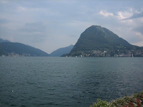
I got to Garsellikopf. This, I later found, was on the border of Liechtenstein and Austria. The marker at the top said 2105 meters and had an arrow with “Drei Schwestern” on it. I had not yet reached the goal. I went down from Garsellikopf and continued along the ridge. This ridge composes a natural border between the two countries. The views on both sides of the ridge were awesome. It is really hard to come up with good adjectives for the beauty of what we take in. Hopefully, my pictures help, but they hardly do it justice.

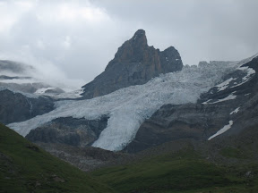
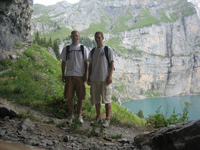
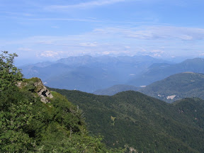
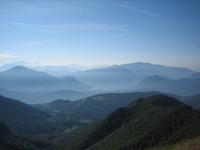
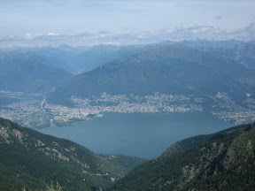
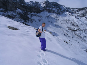
Not long after Garsellikopf I found a sign that said ½ hour more to my goal. At this point I was a little upset with the sign makers because there was no way I could have made it from the first sign to this one in ½ hour, even if I was not tired. After a short break for mumbling, I took a slightly longer one for kissing the new toe injury I received from kicking the sign post; then I continued. Eventually I made it to the first of the Drei Schwestern. I took the following picture sitting with my legs around the marker (it was steep at the top and I was tired). The two crosses on the peaks are the other Sisters. To the left in the foreground is Liechtenstein. To the right is Austria. Farther ahead to the left is Switzerland. And on the other side of the giant lake in the distance is Germany.

On the way down, I made good time. I, in fact, dominated the sign post makers, reaching the bottom in two hours (compared to their expected three, but that's how long they said it would take to summit as well). After those hikes, Bryan and I were exhausted.

As usual, please enjoy perusing the pictures; take a look at our destination map. We'd love to read any comments.

Säntis

This weekend's story once again begins with the overwhelming generosity of our hostel hostess, Marianne. She was not going to be using her car this weekend, so she practically forced us to use it. So, we loaded up the blue Subaru wagon, and set forth with road map in hand.

Despite a noticeable lack of knowledge of laws like the unposted freeway speed-limit and proper round-about etiquette, we arrived safely and without major incident at a little town called Wasserauen, from where we took a chair lift to the beginning of our hike. The weather was pleasant, although a little foggy, our bags were light because we could leave most of our things in the car, and our destination, Säntis, was calling.

Once again, I'll skip over most of the four-hour hike because the pictures give a better description than I can, so we'll pick up the story three and a half hours in. We knew we were getting close to our destination, but because of the fog we really had no idea how close. All we could see was a big snow field in front of us so, learning from past experiences, we switched from our light-footed running shoes to our heavy-duty hiking boots and started the climb. As we ascended with hardly an idea where we were going, the weather gradually became colder, dropping to a frigid 3.5 degrees Celsius (or roughly 40 degrees Fahrenheit). Finally, we came to a 'T' in the hiking path and, not having any signs to guide us, we had to make a decision: climb the peak to the left or climb the peak to the right. We climbed the left peak, which turned out to be the correct peak, and entered the tourist trap known as Säntis.

Our hike to Säntis took us four hours. Most people's lift rides to Säntis took them four minutes. So, we did not have a real solid mountain-top experience this time (unless your idea of a mountain-top experience involves eating nuts—a popular hiking staple in the Burgers' hiking supplies—in a warm restaurant above a souvenir shop) but the fact that we conquered the mountain was good enough for me.

Sleet began to fall as we left. Then, the fog lifted, and we saw a huge weather tower on the top of Säntis, one so big that it not only would have make the choice glaringly obvious which of the two peaks to climb, but would have shown us exactly where we were going through the snow fields. In fact, three hours later when we reached our starting point again, we could still plainly see the tower in the distance.


Having finished our Saturday adventure, we crawled back into the car, found a nice little place to eat pizza, and then went off in search of a good place to sleep for the night...

Happy Father's Day

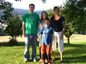
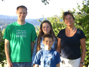
Happy Father's Day, Dad!

You've done tons for us and the four of us are very thankful.

I was thinking this weekend about the when I was about 12. The three of us would complain how we had never flow in an airplane. We had to drive all the way to California (and on the way saw the Grand Canyon and other things) to visit the family and Disneyland. What'd you do? You organized a plane ride for us. I just remember wearing the head set and seeing Grandpa and Grandma's farm. Exhibit #81921 on why you're a great dad.

Thanks! Travis, Rachael, Stephen and Bryan.

Sunday, June 10, 2007

Lake Geneva, Avanches and Bern

This weekend we decided we’d let the snow melt a little more in the mountains and take a break from hiking – but not a break from recreation.

Bryan wanted to go for a bike ride. We read that if we had a security deposit and a passport, we could get free bikes for the day in Lausanne. Well, we could manage both of those – there, we had our regional destination. I also saw some great pictures of a chateau on the lake – there, we had our specific goal. When we inquired about some hostels in the Lake Geneva area, we were surprised to find there was no room in the inns (hostels, at least). But we were stubbornly intent on going out West. Plan B was to go to Lausanne early on Saturday, go for our little bike tour, and return part of the way Saturday night. Finally, we found a hostel in Avenches, but we had to be there by 10pm.

Because of our arrival deadline, we woke up before the early-morning Swiss sun could rise and we set off for Lausanne. We arrived and after a little difficulty, found the bike “rental” location. My heart sunk a little bit when I found out the bikes were cruiser touring bikes, not road bikes or mountain bikes. Later we found that the touring bikes made our necks hurt since everyone passed us so quickly on their road or mountain bikes.


Not long before we got our bikes we found out that the Chateau de Chillion was about 30 km (18 miles) from Lausanne – not the 15-20 km we were thinking. But since we arrived early, and despite our bikes, we thought we could go round-trip and still make the last train that would get us to Avenches. The ride was beautiful. We took a road with a steep hill on the left and the shoreline on the right. The steep hills were covered with grape vines from a number of vineyards. Stunning.


We arrived at the Chateau and took a tour. Then chateau was made famous by a Lord Byron poem set there about how Bonivard was chained to a column in the prison for five years. It was similar to other castles I’ve seen, but it was still interesting.

By the time we returned to Lausanne we were tired – at least I was – Bryan seemed a bit fresher. I was wondering if I hit my 36-mile-wall and Bryan’s was coming at 38 miles or something. I got off my bike and tried to spin the tires to see how they’d work – I thought maybe the brakes were rubbing or something. When I lifted each wheel off the ground and spun it, I could barely get them to spin two rotations with a little push. Bryan’s was working better. At that point, I was very glad I hadn’t tried that before. I’m not sure I would have been willing to ride so far with a bike about as efficient as my old Huffy. We found that we stopped just a little way from the Olympic Museum. We viewed some art in the courtyard of the Olympic Museum and saw the Olympic flame. We then returned the bikes and made it Avenges in time for the 10pm check-in.

Aventicum was once the capital of the Roman province of Helvitica. What was left for us to see in Avenches was a Coliseum-style amphitheater (except without the outer wall) and a few Roman ruins. Early Sunday morning we walked in the footsteps of past Centurions and visited the remains of a theater and a column from an ancient temple. We then both enjoyed our short time in the Roman museum and continued on to Bern.

Bern was crazy when we arrived. There was the Schweizer Fraulaufen, which is an event where every Swiss woman who ever lived ran some course. Coincidentally, every kid was spinning a ratchety, annoying noise-makers provided by Coop. (Bryan and I have since organized a boycott.) We tried our best to avoid the race course and continued through the Swiss capital. The highlights of Bern were the eleven old fountains, the flag-lined streets (I love flags), the clock tower and the bear pits (even though in the five minutes we spent there we took disproportionaly more pictures than in the rest of the city).


As usual, the highlight of the blog is probably the pictures – there are two albums this week, one for the Geneva countryside and one of Avenches (not many) and Bern. We hope you’re enjoying the backseat trip so far – no we’re not there yet. Please let us know if it’s too hot back there, you think we’re taking the corners too fast or you want to listen to a different radio station.

Monday, June 4, 2007

More Hiking Adventures


The plan for this weekend was more hiking.

Marianne (the lady that runs the hostel) and Daniel offered their home in Glarus as our home base for this weekend, so we rode down with them on Friday night, chilled out for a while and slept. In the morning, we were treated to a fantastic breakfast and a pretty solid lunch before heading out for our Saturday afternoon hike. Our weekend plan included a pretty difficult pass on Sunday so we were planning on taking it easy on Saturday.

We jumped on a lift in the early afternoon which took us from the slightly foggy city of Enninda halfway up a very foggy mountain. There was a point on the lift where I could probably only see five feet away from myself. But where the lift stopped it was a little more clear, and we started hiking.

Our hosts told us we should have hiking boots and lent us some of theirs, and we started out in those. After about fifteen minutes of climbing, Travis and I both decided that the boots were ridiculous and we were better off in our running shoes. And as we climbed more, it became very evident why our hosts urged us to wear them: despite the fact that they feel like somebody tied a ball and chain to our feet, the boots kept our feet very, very dry. Without them our feet were soaked within minutes. We climbed a ways more before deciding we had gone far enough, seen enough and wanted to conserve our energy for the next day, so we hiked back down.

That night, we played a sweet game of Cuboro.

Sunday morning started early. We rose before sunrise, ate some breakfast and headed toward the train station, which took us to a bus station, which took us to a road, which took us to a chair lift. Or a Sielbahn if you understand German. I don't. We learned our lesson the day before, so we put on the dry ball-and-chain hiking boots that we borrowed from our hosts and started trudging.


Our trail started up a big mountain covered in white. But not snow—sheep. There was even a shepherd in the field. Many of the sheep were standing on our path, so Travis had to shoo them away before we climbed up the mountain. As we continued to ascend, crossing several roaring rivers on the way, the views just continued to get better. And, as we continued to ascend, the path went from dry to muddy, to a little bit snowy, to really snowy. And then, the path stopped. Well, at least the tracks of other hikers from earlier this year. We could not see the path anymore, because all we could see is snow. We decided, however that we wouldn't let the snow stop us, so we searched around for the trail markers on the rocks and started blazing our own trail through the snow. First, the snow was up to our ankles. A few hundred feet more, up to our boots. Up to our knees. Finally, up to our hips. We were so close to the pass, but we decided it was just too dangereous, since the original trail blazers probably had ropes and not school backpacks; or else went in August. So in the end we decided that we would let the snow stop us.


We came back down to the chairlift, and my feet were screaming "Get me out of these boots!" and if you know me, I don't often argue with my feet when they are screaming, so I obliged. We sat at the chair lift for a while, occassionally using what was probably the second phone Alexander Graham Bell made, spinning a dial to make it ring, calling the bottom hoping somebody would answer to bring us down. But nobody did, so we decided to take the hour-long trail toward the bottom. There was no way our feet were going back in those hiking boots, though, so we laced up our running shoes and started hiking. Our feet were so happy to be in running shoes again, they practically floated down the hill until we started jogging down the path, jumping from rock to rock, taking rivers in a single bound and balancing on tree trunks until we reached the bottom. Then, another bus, a few more trains, a stop in Zurich for some kababs (!!!), and we were back home at the Hostel.

See all photographs

Sunday, May 27, 2007

Glärnischhütte

We went hiking this weekend. The plan while we’re here is to hike quite a bit.


We thought we’d start out easy and work our way into it. There is still snow in the high Alps and it was supposed to rain on Sunday and Monday (I didn’t have to work because apparently the Swiss also celebrate American Memorial Day) so we thought we’d go to a closer place where we could return to Winterthur if we didn’t feel like making a huge weekend out of it.

On the suggestion of our host mom, Marianne, we decided to go to Glarus and then catch bus to Klöntal. She suggested we hike to the Glärnischhütte (a guest hut) near the Glärnisch glacier. She said we could go to the area together because her husband lives in Glarus and she and her kids were going there for the weekend. In our minds, that meant we were going to ride the train there with her. But instead, she gave us a ride and brought us pretty close to the trail head. That was pretty cool.

The Swiss mountains are different than the Rockies, where I’ve been hiking in the past. I can’t exactly put my finger on it, but I’ll try to explain.

First, they seem to rise faster. I mean that you’re on flat ground and then all of a sudden, there’s a sheer cliff. On this hike we walked through a valley for quite a ways. Then we had to climb and climb.


Second, the mountains are greener. There is grass much of the way up, even on the little ledges. This made for a beautiful walk through the valley. There were a number of low volume, high waterfalls. The water from each of these eventually joined together into one river, which flowed through the valley.


After about three hours we reached our goal, the hut. In the above picture you can barely make it out along the left side, about 3/4 of the way up - it's on the ridge with the highest waterfall. At this point, it started to rain so we sat inside a bit, rested and talked to the people running the hut. They told us it’d be another hour to the glacier. After a little break we decided we should see the glacier while we were almost there. This is in the snow area on the top left in the above picture. We didn’t see anyone above the hut and the view of the valley was great. Hiking is one thing that is hard to capture in pictures, as Bryan says, you really have to see it for yourself.

Some of the other guests at the hut said it wasn’t a real glacier with all the blues and colors, but we enjoyed it nonetheless. We got to a place where there was a pretty high snow mass in front of us and could see some cool blue tints. We decided not to go any closer because our reward to risk ratio was very low at that point. We could see all we were going to see and glaciers are very dangerous without the proper tools to help you if you fall into a crevice.

Then we trekked down. When we got to the bottom it was about 6:15. We were planning to catch the bus back into Glarus. The bus left at about 7 so we waited at picnic table near the bus stop. A family of three arrived about 6:30 to wait for the bus as well. We hung out until about 6:50 when the restaurant owner told the family that the bus wouldn’t come at 7 because it wasn’t summer yet. We thought, “Uh oh…now what do we do? Glarus is at least 8km ~ 5 miles and we are really tired.” The other family just started walking and decided to hitchhike. So we did the same. The first vehicle that came was a small Jeep. The family was walking behind us and got a ride. We were a little ways ahead and tried to also get a ride. It worked! First try. We are awesome! It actually worked out quite well because the family could speak German to the driver and the passenger (conversation is polite as a hitchhiker, or so I hear). Also, very few Swiss vehicles could fit 7 people, as this one did with two tight benches in the back. Then, when we got to Glarus, the family was also going to the train station, so we just followed them there. We ended up getting on the slow train, the one that stopped at every…single…town…along the way.

On the trip, we walked at least 10 miles and went up 1350 vertical meters (4400 feet). “That’s an easy hike to get yourself started?” you are asking. You’re right, it’s probably not that easy. But it was a great hike.


See all photographs

Sunday, May 20, 2007

Bryan the prophet said "we're going to burn"

On Friday night Bryan said "we're going to burn." He turned out to be sort of prophetic. Let me explain.

Yesterday we finally got our halbtax, which allows us to buy half price train tickets. We then bought tickets to a soccer game between FC Zurich and Young Boys (Bern). FCZ was in 1st place in the top Swiss league and YB was in 3rd. So we went to Bern (Bryan the prophet). There was a cheaper, extra train going from Zurich to Bern, and we got tickets for that one instead of the normal train. Guess who else was riding? Yep, all the FCZ fans. It was a pretty fun trip to Bern with all the chanting and singing (one song was to the tune of When the Saints go Marching in and another to the theme of Tetris).

When we got to Bern, there were all these riot police at the stadium
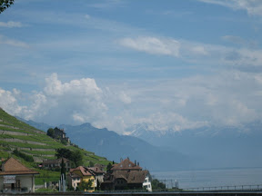
. Our tickets were in the home section - we thought we had seats in the Zürich section. So we jumped bandwagons and cheered for Young Boys during the game. We were in the lower level of the Stade de Suisse and the home crowd was pretty rowdy. FCZ scored in front of us in the first half. Then YB scored in front of us early in the second. FCZ scored about 3 minutes later to go back up one. Then YB scored again to tie it. I took a picture of our section immediately after that. Finally, with about 5 minutes to go, FCZ scored to make it 3-2 and the home fans were stunned.

On the way back, we again rode with the FCZ fans. At first the two across from us talked to me/us a little. They seemed sort of nice. After a while, there weren't being nice though. The one was saying stuff directly to me in German that he knew I couldn't understand and the guy across the aisle from Bryan was wiggling his fingers or something 6 inches from Bryan's face. Then the guy across from me decided not to throw cigarette number 21 out the window with the other 20; instead, he put it out on the garbage can thing between us, and it burned my leg (Bryan the prophet). "Sorry" he said, unconvincingly. But we made it back the rest of the way to Zürich and had awesome Kebaps or Kebabs.

See all photographs

Friday, May 18, 2007

We made it.

We made it: we are here in Switzerland. I'll let you in on a little secret: it does not seem much different than South Dakota or Iowa; other than the facts that, on a good day, I can see the Alps from my window, everybody around me is speaking a language I can not understand, and it took me four days to find a way to get power to my computer. Last time I was in Europe, the whole everybody-is-speaking-gibberish thing was a bit shocking for me, but maybe I am used to it now. Who knows?

So what have we been up to? Settling. Lots of settling, really. And sleeping. To steal a phrase from Travis, I think I slept enough in the past two nights that I shouldn't ever have to sleep again. But that may have been necessary since the seven hour time difference cut out one night's worth of sleeping. We've been getting aquainted with our house-mates, finding food, calculating train tickets, and finally today we both started working. Well, I haven't started working, yet, because I decided to write this blog first, but I'll start working soon enough. But that's all, for now. Leave us some questions in the comment area and we might try to answer some of them in future blogs.

But now, I should start working...

Sunday, May 6, 2007

The Motivation

I am getting really excited about going to Switzerland. This is how it all started.

It was the middle of Fall, 2006 -- at that time, I was in the midst of preparing an application for a summer research position in Southeast Asia. I had spoken to my advisor, Heidi, about it and we were trying to find a place where I could go -- and I was talking to some of my friends, my office-mates. Heidi came into our office and asked me if I wanted to go to Switzerland instead of SE Asia. The company I worked for in Indiana last summer had an office in Switzerland, and they were impressed with the two others from my office who were there at the time. I was applying to go to SE Asia because I thought it'd be an adventure and I could get some experience. Heidi was presenting me with the same deal, only across the Atlantic, not the Pacific. Well, to make this a little shorter, they had a job for me at Zimmer and I took it.

I was in Switzerland for three days in 2002. I loved it. It was my favorite place to visit because it was so natural and I loved the Alps. I am very excited to go back. This map shows Winterthur, in the NE (straight north of the TZ in Switzerland and the L in Italy for those of you who are not geographically inclined), near Zurich. This will be the home-base for what I hope will be one big summer adventure.

Tuesday, May 1, 2007

The Beginning

Here we stand, on the edge of a new beginning. On May 14, 2007, my brother, whom many of you may know simply as 'Travis', and I will be embarking on a Swiss Adventure. We will be calling Winterthur our home, and from what I hear, we'll be residing in a hostel, hopefully full of fun and interesting travelers. We have no intention of hording our adventure; we don't want to keep it all to ourselves! We want you to be part of it! So please, check back every once in a while to see what we're up to; leave us comments, questions, suggestions, or encouragement.

As a picture fitting for the beginning of the trip, Travis posted his passport, complete with his brand new, shiny work visa: