Sunday, July 29, 2007

Blüemlisalp

This week we made a return to Berner Oberland. We drove to Kandersteg and began from there. The first hour of our trek we passed about thirty members of Troop 101, as we called them. This was a disjointed group of kids, maybe 14 years old or so, evidently on a camping/hiking excursion. About an hour into our trek we reached the Oeschinensee. There was a restaurant/hotel there and this was, thankfully, also the final destination for the Troop. We continued along the path to get away from the crowd of kids, many of whom already had reached the lake. We walked on the north side of the lake from west to east and took in the magnificent view. The lake was fed by numerous waterfalls and had a stunning shear cliff making up its east bank.


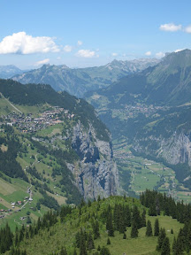
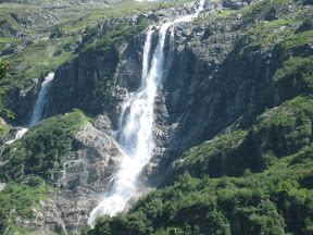
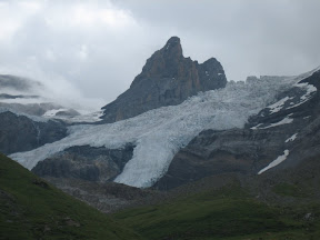
After we climbed out of the valley we found that we were in another, but we could no longer see the lake. Here we could more clearly see one of the sources of the lake: the Blüemlisalp Glacier. The glacier had some loud waterfalls coming from its melting edges. A few spots were a wonderful blue color, but most was a dirty color because it is the middle of summer.


After a few more hours we reached the pass. We climbed a little farther and stopped to rest at the Blüemlisalphütte. Fortunately, we filled up our water at that restaurant because there was no potable water here (then we questioned the potabitality of the water at the restaurant too). We felt a little out of place at the hut. Let me explain. First, the high temperature for Kandersteg was supposed to be 23° C. The temperature drops about 1 degree per 100 meters of elevation change. The hut was 1600 meters above Kandersteg, making it about 7° C (~45° F) max. We (well, thanks to our fearless leader, me) foolishly did not bring any long sleeves or jackets and our hands were a little numb when we reached our goal. Everyone at the hut was wearing their waterproof, windproof hiking gear. We had hiked in cotton t-shirts and shorts. Second, we have noticed that if you hike, you have to wear 3 pound hiking boots, otherwise you can't walk over rocks. Bryan and I both feel much more comfortable and stable in our running shoes. But we did see a pair of tennis shoes on the rack where we got our indoor, hut footwear! They must have been packed along by one of those staying at the hut for the evening. We got a bowl of hot soup and a chocolate bar and warmed up slightly before our descent back to Kandersteg.

About 15 or 20 minutes from the hut, we were already down far enough to be warm again. To that point we had passed a number of other descenders. It was probably because they were bogged down in their hiking boots. (In fact, on the whole day, other than our rest breaks, only at the end when we were marveling at some cool tree carvings did we get passed by someone.)

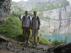
This hike this week was a particularly big one. If you are familiar with the metric system you may have caught I mentioned the magnitude of our ascent: 1600 meters (if not the number didn't mean anything to you). Actually, it was 1660 meters. For those of you who aren't familiar, 1600 meters is 1 mile. If you're from South Dakota or Wisconsin on the Great Plains, every square foot of the plains is exactly 1100 feet. Well, Sioux Falls is about 1400 feet and Madison 900 feet. Denver, the Mile High City, is 5280 feet. The elevation change of our hike was more than the difference between the plains and the base of the Rockies. Because of this, I was a little surprised by the people that we saw in the hut, those who looked down at us foolish kids for wearing tennis shoes and t-shirts. There were a few people of retirement age. A number of others were, well, maybe I should just say that there weren't too many people in their 20s as I would have expected after such a climb. I guess that means we're not so special.


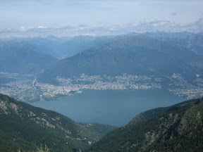
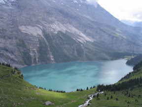
Today we have been paying the price for the hike because we have been hobbling around. But the trip was worth it because we feel a little sense of accomplishment after such a big hike. A better reason that it was worth it was because the lake and glacier were brilliant. Again, it's so hard to describe and it's even better than the pictures can show.

Wednesday, July 25, 2007

Rheinfall

Bonus midweek blog!


A few times this summer Marianne has suggested we go to see the Rheinfall and I heard Mariana say that it was worth seeing. Finally, we decided that it was a good evening to go. Marianne and family went to Italy for a few weeks and left us the car again. We tried to find anyone else who wanted to ride along on the half hour drive to Neuhausen am Rheinfall, but nobody at our place wanted to go.

I had heard claims that the Rheinfall is the biggest waterfall in Europe. When I first heard that statement I wondered what it meant exactly. Tallest waterfall? Nah, Schmadrachfalle (from our last trip) was definitely taller. Most water? Widest? I'm not exactly sure, but I bet it means it is the waterfall with the most volume of water.


The waterfall, or series of falls, occurs at a bend of the Rhein River. The Rhein begins in Switzerland and makes up part of the border between Switzerland and Leichtenstein, Austria and Germany. Later the Rhein makes up about half of the border between Germany and France. Finally it flows through the Netherlands and into the North Sea. In the Netherlands it splits and one part becomes the IJssel [sic], which separates Zwolle and Hattem. These seemingly insignificant towns are where Bryan used to live and went to school, respectively, during his semester in the NED. But enough geography that few beside me really care about.

Back to the falls. I was not expecting them to be quite as big and I was quite impressed. After a little bit of research, we found that they are approximately half as tall with 10% of the volume as Niagara Falls. But I've never seen that and Bryan and I agreed that these were easily the biggest we've ever seen. To add to the experience, the evening was very calm and the peaceful warm weather contrasted nicely with the roaring falls. There was a time where we stared into the falls, mesmerized as if they were a fire.

There isn't really much to write about our quick trip to the falls. Sometimes I think maybe we should just post a link to the pictures instead of writing, because really, they tell the whole story.

Monday, July 23, 2007

this weekend's non-adventure

are you ready for this
we wrote you a rhyme
we’ll make this quick
it won’t take much time

we thought we should ‘splain
why we have nary a pic
why we didn’t go adventuring
or follow guidebook Rick

the forecast called
for clouds and some rain
so here in our room
we thought we should remain

the dark angry clouds
began their Saturday pour
the hall window was open
you shoulda seen the wet floor

someone forgot it
he wasn’t using his head
but he paid the price
with some saturated bread

we stayed in our room
and were quite content
watching the clouds
as projectiles were sent

thunder shook the house
and bright lightning flashed
by then our hopes for a hike
had long since been dashed

we might have been fine
on Sunday afternoon
but after the rain
we felt it was too soon

one weekend at home
is considered a rest
but if there are no more
that would be best

t&b

Sunday, July 15, 2007

Schmadribachfall

"That's a nice picture." Yep, that's what I just heard while Travis was uploading the pictures today. And once again, this week the story is in the pictures. Go ahead, go and look at them right now if you'd like, I won't be offended. The blog will still be here when you return.


We went hiking again this weekend. This time, we went to central Switzerland to a place a little south of Interlaken, which we wrote about last week. Travis' boss Robert was taking his three-year-old son to Interlaken and so we hitched a ride with him, and Rick Steves (the author of our Switzerland guide book) tipped us off about a hike from a little non-touristy town named Gimmewald. We had to take a lift up to Gimmewald, and it did seem like a fairly down to earth little village; at least all of the houses were made of unpainted wood.


The first stretch of our hike was difficult. We walked up what seemed to be a 45 degree incline for about an hour, and to make matters worse there was very little of a view to make us feel better about our sweat-drenched shirts and complaining lungs. But after that first hour, we realized it was worth it. Well, more accurately, after we passed the bulls that were guarding the path, standing right on our path looking straight at us, and demanding that we answer them these questions three (I got one wrong and Travis rescued me from the Gorge of Eternal Peril, but that's a different story for a different time), we were allowed to pass and we realized it was worth it. And here's why: we reached a high point called Tanzebödeli where we could see out over the fertile valley with its quaint mountain villages and across the valley to three looming white-peaked mountans and two lively water falls, and it was breathtaking. Well, it would have been if the difficult climb hadn't already taken my breath.


Our trip down the other side of the mountain was much easier and we had a good view of Schmadribachfall nearly the entire way down. That's the big waterfall in the pictures. And that was our first trip to the Berner Oberland. We fully plan on going again soon, and you can be sure that when we do, we'll take even more pictures.

Sunday, July 8, 2007

Fast-Forward Sightseeing

What a tour book writer could see in a week, Travis and I did in one whirl-wind tour of a day. In other words, if a normal trip through Switzerland is a movie played at normal speed; Travis' and my Saturday was the same movie in fast forward. Basically what I'm getting at is that we mananged to visit three of Switzerland's top attractions in one day: Zermatt, Interlaken, and Zurich.


Tracking the Zermatt weather for the past week, we were convinced that the weather would be pristene on our trip to see the famous Matterhorn. We had heard, and Travis had experienced, that often the weather around the Matterhorn is foggy and hazy and there is not really a good view of the mountain; however, while we sat and stared at the mountain, there was not even one cloud in the bright blue sky. I think the pictures are the best way for you to vicariously experience the mountain jutting straight up. After spending about two hours in Zermatt, we jumped on the train and headed back down the mountain toward a town called Interlaken.


Interlaken means "between lakes," so we made a point to see one. But Interlaken is also a very touristy area, so we made a point to browse a few souveneir shops on the way. After walking on the main shopping street for a kilometer or two, we veered off the main road and found the Aare River which connects the Thunersee and Brienzersee (the two lakes) and followed it to Brienzersee. We soaked in the scenery—the huge blue lake with a bunch of mountains in the background framed by the big blue sky—from a small dock. Actually, just go and look at the pictures for this one, too.


Zurich, although it was not on the original itinerary, has a great place to buy Doner Kabobs in the train station, so, since we were hungry and since Zurich is almost always on our way back to Winterthur, we decided to grab some of the seasoned lamb. Upon arriving in Zurich, Travis remembered someone telling us earlier that week that it was Zuri-fest, a huge festival. Since it was only 8:00pm, we decided to see what all of the hubbub was about. A few other people also decided to see what it was about, and pretty soon we were in the middle of a huge crowd and could barely move. There was some music, but none that really appealed to either one of us—it was much more fun just to dodge in and out of diverse mob of people present as quickly as possible than to listen to the techno that was blaring on the side streets or the German music on the main stage.

Eventually, we navigated the singing and dancing crowds back to the train station. But the day ended as the rest had gone, in fast forward. We made use of our people-dodging, through-crowd-weaving practice by sprinting through half of Switzerland's busiest train station to catch our Inter-City back to home-sweet-home Winterthur. On the train back we refelected on our wild day—we awoke before dawn, spent a total of 11 hours on trains (luckily we purchased day cards and got more than our money's worth out of them) and saw several of the major Switzerland tourist attractions. The sights made all the travel well worth it, and frankly, we wouldn't have it any other way.

Sunday, July 1, 2007

Ticino

As more entries are crossed off our "Places to Visit" list, the remaining locations are becoming farther away. We looked at the weather and the Ticino region promised to be the driest of those remaining. After we decided where to go, we told Marianne and asked for input. And, in what is becoming a pattern, she gave us advice and offered us her car.

On Friday I got off work a little after noon and we drove through the 17 km (10ish mile) Gotthard tunnel to the canton of Ticino in the Italian region of Switzerland. We arrived in Lugano and walked around a little bit. Lugano was beautiful – it's a city right on a lake with hills rising right out of the water. But it is not the most exciting town and we had reserved rooms elsewhere and left after only a few hours.


We then navigated a narrow, curvy road up to Miglieglia. The straight portions were about 10 car lengths long and I was a little nervous. When rounding one left-hand curve heading up hill, I was minding my business, driving on my own side of the road, safely, and I met a Jeep that came whipping around the curve well over the line. He promptly made his tires squeal but didn't appear to want to return fully to his lane; still, everything turned out OK.

After arriving in the town of Miglieglia, we immediately saw the lift that we planned to ride up to Monte Lema where we would stay in a hotel with the same name as the mountain. We parked the car and found that the lift closed at 5:30 for the evening. It was 7:30. We were late. We were a little disappointed, but fortunately we have been practicing our hiking and we unexpectedly hiked up about 2000 feet to our hotel. As we reached the top, we saw the high Alps rise like the sun above the ridge. Wow. We were shown our "dormatory" style room and found that we had the 10 beds to ourselves. We then took a brief walk into Italy and went to bed early.

On Saturday morning we trekked up and down along the top of the ridge to Monte Tamaro. In the morning it was clear to the west and we could see to the snow-covered high Alps in central Switzerland. In the east it was a little hazier, but we were still impressed with the hilly Ticino.


About half way to Monte Tamaro we saw our first hikers. As we approached we saw more and more because there was a lift much closer to Monte Tamaro than the one we wanted to take. By the time we summitted, there were many others. Am I selfish if I walk about 6 miles, see about 8 people all morning, then have to share the peak with 15 others? Nonetheless, the view was awesome. At 1962 m, we towered above Locarno and Lake Maggiore (193 m). We hiked back to Monte Lema, making it a game to catch everyone in front of us. We caught everyone we saw, except for two groups of two, one of whom we would have passed if they didn't take the other trail three minutes from Monte Lema. That's right, I'm still bitter.


This time, we caught the lift down. Back in the car, on the road to the freeway, I was beginning to miss the road we took up to Miglieglia. Now the road was about a lane-and-a-half wide and it was even curvier! – in one section there were about 8 hairpins in a row. Fortunately, the other drivers were more well-behaved than on the way up; still I was terrified. The only incident we had was when I faced off with a bus like two rams fighting for a ewe. I changed my mind and decided that the ewe wasn't even that attractive. I pulled into a driveway so the bus could take his conquest on the one-lane section of road and saved my horns for one with shinier wool and smoother hooves.

Ticino was much different than the higher mountians we've climbed already, but we still enjoyed the different scenery. Possibly, more importantly, the new marker adds breadth to our map. The weekend seemed a little less eventful than the previous ones, maybe because as I look back, this is the first weekend in June we haven't been gone on both Saturday and Sunday. It is good to take a little break today.

"What remains on that list of yours?" you ask. SPOILER ALERT. Among our plans is to meander near the Matterhorn and take a jaunt or two in the Jungfrau region. Stay tuned...